
NCERT Solutions for Class 9 SST Chapter 2 Shaping of the Earth’s Surface
Table of Contents
Page No. 13 The Big Questions
Question 1:
What shapes the Earth’s surface?
पृथ्वी की सतह को कौन-कौन सी चीज़ें आकार देती हैं?
Answer
The Earth’s surface is shaped by two main types of forces:
(1) Internal (Endogenic) Forces – These originate inside the Earth and include Earthquakes, Volcanic, eruptions, Folding, Faulting, Movement of tectonic plates. These forces create major landforms like mountains, valleys, and ocean basins.
(2) External (Exogenic) Forces – These act on the Earth’s surface and include Weathering, Erosion. These forces gradually wear down and reshape the land through agents such as running water, wind, glaciers, sea waves, and underground water.
पृथ्वी की सतह को दो प्रकार की शक्तियाँ आकार देती हैं:
(1) आंतरिक (अंतर्जात) शक्तियाँ – जैसे भूकंप, ज्वालामुखी, वलन, भ्रंश और प्लेटों की गति।
(2) बाहरी (बहिर्जात) शक्तियाँ – जैसे अपक्षय, अपरदन और निक्षेपण, जो जल, हवा, हिमनद, समुद्री लहरों और भूमिगत जल द्वारा कार्य करती हैं।
ये सभी शक्तियाँ मिलकर पर्वत, मैदान, घाटियाँ, डेल्टा आदि स्थलरूपों का निर्माण और परिवर्तन करती हैं।
Thank you for reading this post, don't forget to subscribe!
Question 2:
What is plate tectonics? What are the effects of plate movement?
प्लेट विवर्तनिकी क्या है? प्लेटों की गति के क्या प्रभाव होते हैं?
Answer
Plate tectonics is a theory given by W. J. Morgan. According to this theory, the Earth’s outermost layer (the lithosphere) is broken into several large and small pieces called tectonic plates. These plates move slowly over the semi-molten layer (the asthenosphere) beneath them.
Effects of Plate Movement:
The movement of tectonic plates:
(1) Forms mountains and valleys.
(2) Creates ocean basins.
(3) Causes earthquakes.
(4) Leads to volcanic eruptions.
(5) Explains the distribution of continents and oceans.
प्लेट विवर्तनिकी एक सिद्धांत है जिसे डब्ल्यू. जे. मॉर्गन ने दिया। इस सिद्धांत के अनुसार पृथ्वी की बाहरी कठोर परत (लिथोस्फीयर) कई बड़ी और छोटी विवर्तनिक प्लेटों में विभाजित है। ये प्लेटें नीचे स्थित अर्ध-द्रवित परत (एस्थेनोस्फीयर) पर धीरे-धीरे गति करती हैं।
प्लेटों की गति के प्रभाव:
(1) पर्वतों और घाटियों का निर्माण होता है।
(2) महासागरीय बेसिन बनते हैं।
(3) भूकंप आते हैं।
(4) ज्वालामुखी विस्फोट होते हैं।
(5) महाद्वीपों और महासागरों का वितरण स्पष्ट होता है।
(6) अधिकांश भूकंप और ज्वालामुखी प्लेटों की सीमाओं, विशेषकर रिंग ऑफ फायर, के आसपास पाए जाते हैं।
Question 3:
How are landforms formed and how are they classified?
स्थलरूप कैसे बनते हैं और उनका वर्गीकरण कैसे किया जाता है?
Answer
Landforms are natural features on the Earth’s surface. They are formed by:
(1) Internal forces such as plate movements, earthquakes, and volcanic activity.
(2) External forces such as weathering, erosion, and deposition. These processes continuously shape and reshape the Earth’s surface over time.
Classification of Landforms:
Landforms are classified according to the natural agents that form them:
(1) Landforms formed by running water – Waterfalls, meanders, deltas, floodplains.
(2) Landforms formed by waves and currents – Beaches, sea cliffs, sea caves, arches, stacks.
(3) Landforms formed by glaciers – U-shaped valleys, cirques, moraines, fjords.
(4) Landforms formed by wind – Sand dunes, yardangs, ventifacts, deflation hollows.
स्थलरूप पृथ्वी की सतह पर पाए जाने वाले प्राकृतिक भू-आकार हैं। इनका निर्माण:
(1) आंतरिक शक्तियों (प्लेटों की गति, भूकंप, ज्वालामुखी) तथा
(2) बाहरी शक्तियों (अपक्षय, अपरदन और निक्षेपण) द्वारा होता है।
स्थलरूपों का वर्गीकरण:
स्थलरूपों का वर्गीकरण उन्हें बनाने वाले प्राकृतिक कारकों के आधार पर किया जाता है:
(1) बहते जल द्वारा – जलप्रपात (Waterfall), विसर्प, डेल्टा, बाढ़ मैदान।
(2) समुद्री लहरों और धाराओं द्वारा – बीच, समुद्री चट्टान, समुद्री गुफा, मेहराब, स्टैक।
(3) हिमनदों द्वारा – U-आकार की घाटी, सर्क, मोरेन, फियोर्ड।
(4) वायु द्वारा – बालू के टीले, यार्डांग, वेंटीफैक्ट, डिफ्लेशन होलो।
(5) भूमिगत जल द्वारा – गुफाएँ, स्टैलेक्टाइट, स्टैलेग्माइट, सिंकहोल।
Question 4:
How are humans and other living beings connected to these landforms?
मनुष्य और अन्य जीव-जंतु इन स्थलरूपों से किस प्रकार जुड़े हुए हैं?
Answer
Humans and other living beings are closely connected to landforms because they provide habitats, water, fertile soil, natural resources, and suitable conditions for life.
(1) Plains and river valleys provide fertile soil for agriculture and support dense human settlements.
(2) Mountains provide forests, fresh water, and habitats for many plants and animals.
(3) Rivers, lakes, and deltas supply water, support fishing, irrigation, transportation, and wildlife.
(4) Beaches and coastal areas support tourism, fishing, and protect coastal settlements.
(5) Different landforms also influence climate, vegetation, occupations, culture, and biodiversity.
मनुष्य और अन्य जीव-जंतु स्थलरूपों से घनिष्ठ रूप से जुड़े हुए हैं, क्योंकि ये उन्हें आवास, जल, उपजाऊ मिट्टी, प्राकृतिक संसाधन और जीवन के लिए अनुकूल वातावरण प्रदान करते हैं।
(1) मैदान और नदी घाटियाँ कृषि तथा मानव बस्तियों के लिए उपयुक्त हैं।
(2) पर्वत वन, मीठे जल के स्रोत और अनेक जीव-जंतुओं के आवास प्रदान करते हैं।
(3) नदियाँ, झीलें और डेल्टा सिंचाई, मत्स्य पालन, पेयजल तथा वन्यजीवों के लिए महत्वपूर्ण हैं।
(4) समुद्री तट पर्यटन, मत्स्य पालन और तटीय क्षेत्रों की सुरक्षा में सहायक हैं।
(5) स्थलरूप जलवायु, वनस्पति, जीव-जंतुओं, मानव जीवन, व्यवसाय और संस्कृति को भी प्रभावित करते हैं।
Question 5:
How do disasters associated with different landforms impact human lives?
विभिन्न स्थलरूपों से संबंधित आपदाएँ मानव जीवन को किस प्रकार प्रभावित करती हैं?
Answer
Disasters associated with different landforms, such as landslides, avalanches, Glacial Lake Outburst Floods (GLOFs), and dust storms, have serious effects on human lives. They:
(1) Cause loss of life and property.
(2) Damage houses, roads, bridges, and other infrastructure.
(3) Destroy crops, forests, and livestock.
(4) Disrupt transport, communication, and livelihoods.
(5) Force people to leave their homes and create environmental damage.
विभिन्न स्थलरूपों से संबंधित आपदाएँ, जैसे भूस्खलन, हिमस्खलन, ग्लेशियल लेक आउटबर्स्ट फ्लड और धूल भरी आँधी, मानव जीवन पर गंभीर प्रभाव डालती हैं। ये:
(1) जान-माल की हानि करती हैं।
(2) घर, सड़कें, पुल और अन्य बुनियादी ढाँचे को नुकसान पहुँचाती हैं।
(3) फसलों, वनों और पशुधन को नष्ट करती हैं।
(4) यातायात, संचार और आजीविका को बाधित करती हैं।
(5) लोगों को अपने घर छोड़ने पर मजबूर कर सकती हैं तथा पर्यावरण को भी नुकसान पहुँचाती हैं।
NCERT Solutions for Class 9 SST Chapter 2 Shaping of the Earth’s Surface
Page No. 37 Questions and activities
Question 1:
What are the sources of energy that are required to cause movements associated with the internal forces of the Earth?
पृथ्वी की आंतरिक शक्तियों से संबंधित गतियों को उत्पन्न करने के लिए आवश्यक ऊर्जा के स्रोत कौन-कौन से हैं?
Answer
The movements caused by the Earth’s internal forces are driven mainly by heat energy from inside the Earth. This heat comes from two sources: the residual heat left from the Earth’s formation and the heat produced by the decay of radioactive elements. These energy sources create convection currents in the mantle, which move tectonic plates. As a result, earthquakes, volcanic eruptions, folding, and faulting take place, continuously reshaping the Earth’s surface.
पृथ्वी की आंतरिक शक्तियों से होने वाली गतियों के लिए मुख्य ऊर्जा स्रोत पृथ्वी के भीतर की ऊष्मा ऊर्जा है। यह ऊष्मा दो स्रोतों से प्राप्त होती है—पृथ्वी के निर्माण के समय बची हुई अवशिष्ट ऊष्मा तथा रेडियोधर्मी तत्वों के विघटन से उत्पन्न ऊष्मा। यह ऊर्जा मैंटल में संवहन धाराएँ उत्पन्न करती है, जिससे विवर्तनिक प्लेटें गतिशील होती हैं। परिणामस्वरूप भूकंप, ज्वालामुखी, वलन तथा भ्रंशन जैसी प्रक्रियाएँ होती हैं और पृथ्वी की सतह निरंतर बदलती रहती है।
Question 2:
Relate various physiographic divisions you have studied in the earlier grades with various endogenic forces responsible for their origin.
आपने पूर्व कक्षाओं में जिन विभिन्न स्थलाकृतिक (भौतिक) विभागों का अध्ययन किया है, उन्हें उनकी उत्पत्ति के लिए उत्तरदायी विभिन्न अंतर्जात बलों से संबंधित कीजिए।
Answer
Different physiographic divisions are formed by different endogenic forces. Fold mountains like the Himalayas were formed by compressional forces due to the collision of tectonic plates. Block mountains and rift valleys are formed by faulting caused by tensional forces. Plateaus, such as the Deccan Plateau, were formed mainly by volcanic activity and uplift. Earthquakes and volcanic eruptions also modify landforms, continuously shaping the Earth’s surface.
विभिन्न स्थलाकृतिक विभागों का निर्माण अलग-अलग अंतर्जात बलों से होता है। हिमालय जैसे वलित पर्वत विवर्तनिक प्लेटों की टक्कर से उत्पन्न संपीड़न बलों के कारण बने हैं। भ्रंशित पर्वत और रिफ्ट घाटियाँ तनाव बलों से होने वाले भ्रंशन द्वारा बनती हैं। दक्कन का पठार मुख्यतः ज्वालामुखीय गतिविधियों तथा भू-उत्थान से बना है। भूकंप और ज्वालामुखी विस्फोट भी स्थलरूपों में परिवर्तन लाकर पृथ्वी की सतह को निरंतर आकार देते रहते हैं।
Question 3:
Why and where do earthquakes occur frequently? Is it possible to predict earthquakes?
भूकंप बार-बार क्यों और कहाँ आते हैं? क्या भूकंपों की भविष्यवाणी करना संभव है?
Answer
Earthquakes occur frequently along tectonic plate boundaries where plates collide, move apart, or slide past one another. These regions include the Pacific Ring of Fire, the Himalayan belt, and mid-ocean ridges. Earthquakes happen due to the sudden release of energy stored in rocks. Although scientists can identify earthquake-prone areas and monitor seismic activity, it is not yet possible to accurately predict the exact time, place, and magnitude of an earthquake.
भूकंप मुख्यतः विवर्तनिक प्लेटों की सीमाओं पर बार-बार आते हैं, जहाँ प्लेटें टकराती हैं, अलग होती हैं या एक-दूसरे के समानांतर खिसकती हैं। ऐसे क्षेत्र प्रशांत महासागर का रिंग ऑफ फायर, हिमालयी क्षेत्र तथा मध्य-महासागरीय पर्वतमालाएँ हैं। भूकंप चट्टानों में संचित ऊर्जा के अचानक मुक्त होने से आते हैं। वैज्ञानिक भूकंप-संभावित क्षेत्रों की पहचान और निगरानी कर सकते हैं, लेकिन भूकंप के सही समय, स्थान और तीव्रता की सटीक भविष्यवाणी अभी संभव नहीं है।
Question 4:
“Plate movements are responsible for the distribution of earthquakes and volcanoes.” Explain.
“प्लेटों की गति भूकंपों और ज्वालामुखियों के वितरण के लिए उत्तरदायी है।” व्याख्या कीजिए।
Answer
The movement of tectonic plates causes earthquakes and volcanic activities. Most earthquakes and volcanoes occur along the boundaries of tectonic plates where plates collide, separate, or slide past each other. When plates collide, one plate may sink below another, causing earthquakes and volcanic eruptions. The Pacific Ring of Fire is an important example where frequent earthquakes and volcanoes occur due to plate movements. Thus, plate movements control the distribution of these activities.
विवर्तनिक प्लेटों की गति के कारण भूकंप और ज्वालामुखीय गतिविधियाँ उत्पन्न होती हैं। अधिकांश भूकंप और ज्वालामुखी प्लेटों की सीमाओं पर पाए जाते हैं, जहाँ प्लेटें आपस में टकराती हैं, अलग होती हैं या एक-दूसरे के पास से खिसकती हैं। प्लेटों के टकराने पर एक प्लेट दूसरी के नीचे धँस सकती है, जिससे भूकंप और ज्वालामुखी विस्फोट होते हैं। प्रशांत महासागर का रिंग ऑफ फायर इसका प्रमुख उदाहरण है। इसलिए प्लेटों की गति इनके वितरण को नियंत्रित करती है।
Question 5:
Draw and label a diagram of a meander and a delta.
एक विसर्प (Meander) और एक डेल्टा (Delta) का चित्र बनाकर उन्हें नामांकित कीजिए।
Answer
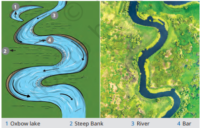
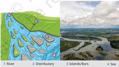
Question 6:
How are deforestation and erosion associated with each other? Explain.
वनों की कटाई और अपरदन एक-दूसरे से किस प्रकार संबंधित हैं? समझाइए।
Answer
Deforestation and erosion are closely related because trees help to hold soil together with their roots. When forests are cut down, the soil becomes loose and is easily removed by wind and water. This increases soil erosion and reduces soil fertility. Deforestation also disturbs the natural balance of the environment and can lead to problems like floods and land degradation. Therefore, forests play an important role in preventing erosion.
वनों की कटाई और अपरदन एक-दूसरे से घनिष्ठ रूप से जुड़े हुए हैं क्योंकि पेड़ों की जड़ें मिट्टी को बाँधकर रखती हैं। जब जंगलों को काट दिया जाता है, तो मिट्टी ढीली हो जाती है और हवा तथा जल द्वारा आसानी से बह जाती है। इससे मृदा अपरदन बढ़ता है और मिट्टी की उर्वरता कम हो जाती है। वनों की कटाई से पर्यावरण का संतुलन भी बिगड़ता है और बाढ़ तथा भूमि क्षरण जैसी समस्याएँ उत्पन्न हो सकती हैं।
Question 7:
Develop a plan to protect the land in your local area from erosion.
अपने स्थानीय क्षेत्र की भूमि को अपरदन से बचाने के लिए एक योजना तैयार कीजिए।
Answer
To protect land from erosion in my local area, we should plant more trees and protect existing forests. Grass and other plants should be grown to hold the soil firmly. Proper drainage systems should be developed to control water flow. Farmers should use methods like contour ploughing and terrace farming on slopes. Avoiding overgrazing, reducing deforestation, and spreading awareness among people can help conserve soil and prevent erosion.
अपने स्थानीय क्षेत्र की भूमि को अपरदन से बचाने के लिए अधिक से अधिक पेड़ लगाए जाने चाहिए और मौजूदा वनों की रक्षा करनी चाहिए। घास तथा अन्य पौधे लगाकर मिट्टी को मजबूती से बाँधा जा सकता है। जल के बहाव को नियंत्रित करने के लिए उचित जल निकासी व्यवस्था होनी चाहिए। ढलानों पर समोच्च जुताई और सीढ़ीदार खेती अपनानी चाहिए। अतिचारण और वनों की कटाई को रोककर लोगों में जागरूकता फैलानी चाहिए।
Question 8:
Which disasters do you think you might experience in your region? Discuss a mitigation plan in your classroom.
आपके क्षेत्र में आप किन आपदाओं का अनुभव कर सकते हैं? अपनी कक्षा में उनके शमन योजना पर चर्चा कीजिए।
Answer
In my region, possible disasters include floods, earthquakes, heat waves, and storms. A mitigation plan should include creating awareness about disaster safety, preparing emergency kits, and conducting regular drills in schools. People should protect the environment by planting trees and avoiding activities that increase risks. Proper drainage systems, strong buildings, and early warning systems can help reduce the impact of disasters and protect lives and property.
मेरे क्षेत्र में बाढ़, भूकंप, गर्मी की लहरें और तूफान जैसी आपदाएँ आ सकती हैं। आपदाओं के प्रभाव को कम करने के लिए लोगों में जागरूकता फैलानी चाहिए, आपातकालीन किट तैयार रखनी चाहिए और विद्यालयों में नियमित अभ्यास करवाने चाहिए। पर्यावरण की रक्षा के लिए पेड़ लगाने चाहिए और जोखिम बढ़ाने वाली गतिविधियों से बचना चाहिए। उचित जल निकासी व्यवस्था, मजबूत भवन और पूर्व चेतावनी प्रणाली आपदाओं के नुकसान को कम करने में सहायक होती हैं।
Question 9:
Prepare a model of landforms created by underground water.
भूमिगत जल द्वारा निर्मित स्थलरूपों का एक मॉडल तैयार कीजिए।
Answer
A model of landforms created by underground water can show karst topography. Use clay, cardboard, and coloured paper to make a limestone region. Show underground water dissolving limestone and forming features like caves, caverns, stalactites, and stalagmites. Label all the parts clearly. This model explains how groundwater acts on soluble rocks and creates different landforms through the process of erosion and deposition.
भूमिगत जल द्वारा निर्मित स्थलरूपों का मॉडल कार्स्ट स्थलाकृति को दर्शा सकता है। इसके लिए मिट्टी, गत्ते और रंगीन कागज का उपयोग करके चूना-पत्थर क्षेत्र का मॉडल बनाइए। इसमें भूमिगत जल द्वारा चूना-पत्थर के घुलने से बनने वाली गुफाएँ, कंदराएँ, स्टैलेक्टाइट और स्टैलेग्माइट जैसी आकृतियाँ दिखाइए। सभी भागों को स्पष्ट रूप से नामांकित कीजिए। यह मॉडल बताता है कि भूमिगत जल अपरदन और निक्षेपण द्वारा विभिन्न स्थलरूपों का निर्माण करता है।
Question 10:
What precautionary measures will you take if you are staying in an earthquake-prone region?
यदि आप भूकंप-प्रवण क्षेत्र में रह रहे हैं तो आप कौन-कौन से सावधानीपूर्ण उपाय अपनाएँगे?
Answer
If I live in an earthquake-prone region, I will take safety measures such as constructing earthquake-resistant buildings and securing heavy objects properly. I will keep an emergency kit with essential items and learn safety practices like “Drop, Cover, and Hold.” I will avoid panic during an earthquake and move to open areas after the shaking stops. Regular disaster drills and awareness can help reduce damage and save lives.
यदि मैं भूकंप-प्रवण क्षेत्र में रह रहा हूँ, तो मैं भूकंपरोधी भवनों का निर्माण करवाने और भारी वस्तुओं को सुरक्षित रखने जैसे उपाय अपनाऊँगा। मैं आवश्यक वस्तुओं वाली आपातकालीन किट तैयार रखूँगा और “नीचे झुकें, ढकें और पकड़े रहें” जैसे सुरक्षा उपाय सीखूँगा। भूकंप के समय घबराने से बचूँगा और कंपन रुकने के बाद खुले स्थान पर जाऊँगा। नियमित अभ्यास और जागरूकता से नुकसान को कम किया जा सकता है।
Question 11:
Prepare a map showing landform-associated disasters that happened in the current calendar year.
वर्तमान कैलेंडर वर्ष में हुई स्थलरूप-संबंधी आपदाओं को दर्शाने वाला एक मानचित्र तैयार कीजिए।
Answer
To prepare the map, mark the major landform-associated disasters that occurred in the current year on an outline map of India. Use different symbols and colours for each disaster:
- Earthquakes: Mark earthquake-affected areas such as Himachal Pradesh, Jammu & Kashmir, and other Himalayan regions.
- Landslides: Mark Uttarakhand, Himachal Pradesh, and Northeast India.
- Floods: Mark flood-prone regions like Assam, Bihar, and Kerala.
- Cyclones: Mark coastal areas such as Odisha, West Bengal, and Gujarat.
भारत के रेखा मानचित्र पर वर्तमान वर्ष में हुई प्रमुख स्थलरूप-संबंधी आपदाओं को अलग-अलग संकेतों और रंगों द्वारा दर्शाइए:
- भूकंप: हिमाचल प्रदेश, जम्मू-कश्मीर तथा अन्य हिमालयी क्षेत्रों को चिह्नित करें।
- भूस्खलन: उत्तराखंड, हिमाचल प्रदेश और पूर्वोत्तर भारत के क्षेत्रों को दर्शाएँ।
- बाढ़: असम, बिहार और केरल जैसे बाढ़ प्रभावित क्षेत्रों को दिखाएँ।
- चक्रवात: ओडिशा, पश्चिम बंगाल और गुजरात के तटीय क्षेत्रों को चिह्नित करें।
Question 12:
Create a poster showing landforms that are considered to be sacred or important in your region, and add the folk stories associated with them.
अपने क्षेत्र के उन स्थलरूपों को दर्शाते हुए एक पोस्टर तैयार कीजिए जिन्हें पवित्र या महत्वपूर्ण माना जाता है और उनसे जुड़ी लोक कथाएँ लिखिए।
Answer
Question 13:
Document a case of a disaster that hit your region in the past, highlighting its effects on various human activities.
अतीत में आपके क्षेत्र में आई किसी आपदा का विवरण दीजिए और विभिन्न मानवीय गतिविधियों पर उसके प्रभावों को बताइए।
Answer
Case Study: Floods in Delhi (2023)
In 2023, severe floods affected parts of Delhi due to heavy rainfall and rising water levels of the Yamuna River. The disaster disrupted transport, damaged houses, affected businesses, and disturbed daily life. Schools and offices were temporarily closed in some areas. Many people were evacuated to safer places. The event showed the importance of proper drainage systems, disaster preparedness, and environmental management.
केस अध्ययन: दिल्ली में बाढ़ (2023)
वर्ष 2023 में भारी वर्षा और यमुना नदी के जलस्तर में वृद्धि के कारण दिल्ली के कई क्षेत्रों में गंभीर बाढ़ आई। इस आपदा से परिवहन व्यवस्था प्रभावित हुई, घरों को नुकसान पहुँचा, व्यापारिक गतिविधियाँ बाधित हुईं और लोगों का दैनिक जीवन प्रभावित हुआ। कुछ क्षेत्रों में स्कूल और कार्यालय बंद किए गए। कई लोगों को सुरक्षित स्थानों पर पहुँचाया गया। इस घटना ने आपदा प्रबंधन, उचित जल निकासी और पर्यावरण संरक्षण के महत्व को दिखाया।
Question 14:
Translate the given poster on landslide into your native language and display it in your home.
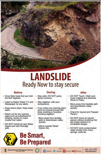
Question 15:
Divide the class into three groups. Each group will work on one project (water, wind, and glacier). The project should highlight the causes, impact on human life and the environment, and mitigation measures.
NCERT Solutions for Class 9 SST Chapter 2 Shaping of the Earth’s Surface
